The Musical Stone — May 2026

The old railroad grade, sandstone ledge on the right — the valley holding its own record.
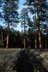
The sky was the color of pewter and the wind had teeth. Eileen and I rolled out from the north side of Emlenton on the morning of May 23rd on a ten-mile e-bike ride that no reasonable person would have scheduled in that weather. We did it anyway, and I’m glad we did.
The Allegheny River Trail runs thirty miles of mostly flat, smooth asphalt from Emlenton north to Franklin, built on the old railroad grade that once carried oil and pig iron down this valley. The sandstone ledge walls cut for the original rail line still line sections of the route — exposed geology, the valley holding its own record. The trail runs bordered on the west by the river and on the east mostly by woodland, a natural corridor that offers abundant wildlife and scenic vistas even when the sky is refusing to cooperate. It’s part of the larger Erie to Pittsburgh Trail, an emerging 270-mile network connecting western Pennsylvania and western New York through hiking, biking, and paddling.


The Erie to Pittsburgh Trail connects 270 miles of western Pennsylvania and New York. Emlenton is the southern anchor of the Allegheny River Trail segment.
Mile marker 101 sits quietly along the trail near the river’s edge — one concrete post bearing two Erie to Pittsburgh Trail medallions facing north and south, marking where you stand in the long corridor between the two cities.

Mile 101 of the Erie to Pittsburgh Trail. Erie is 169 miles north. Pittsburgh is behind you.
The river was running high and muddy, carrying the color of a spring that hadn’t finished its argument with the hills. A strong breeze moved through the tree canopy overhead. We had the trail nearly to ourselves. What the clouds took away in warmth and color they gave back in atmosphere — the valley folded around us, the river gray-green and muscular beside us, glimpsed through the May canopy in pieces, the woodland dripping and alive.

The Ohi’yo, running high and muddy on May 23rd, seen through the canopy from the trail’s edge.
Merlin was listening. At 4:50 that afternoon — coordinates 41.232, -79.739 — the app picked up five birds in sixty-five seconds of ambient sound: American Goldfinch, Red-eyed Vireo, Red-bellied Woodpecker, Hooded Warbler, Baltimore Oriole. A Baltimore Oriole on a cold and overcast late May afternoon, singing anyway. We also spotted a deer standing in the treeline, watching us pass with that particular stillness deer have — not alarm, just assessment. The trail was beautiful even under those conditions. Perhaps especially under those conditions.

Merlin caught five species in 65 seconds at coordinates 41.232, -79.739. The Baltimore Oriole was singing in the cold.
This River Is Not New to Me
My brother Ben and I have fished the Allegheny just south of Emlenton over the years, working the banks the way you do when a river is familiar enough to read. And before Ben and I were old enough to fish it on our own, my father took me south of Pittsburgh for carp and catfish — the kind of fishing that teaches patience more than technique. Those trips are gone now, but the river is the same river.
The earliest Allegheny story I carry happened on the river itself, just outside the town of West Hickory in Forest County — not far from where my aunt had a camp on West Hickory Creek that we visited on trips from Pittsburgh. It was the mid-1960s. Kinzua Dam was in the midst of filling — the entire upper Allegheny watershed reconfiguring itself around a new impoundment — and my father dropped Ben and me off along the bank with our spin rods and tackle box. Ben was young enough that I was keeping an eye on him. I tied on a six-inch plug of my father’s and made my first cast, working the lure in twitches along the shore. And then: a shape materialized out of the dark water — the unmistakable sideways swirl of a muskellunge, the ghost of the river, closing on the plug and then turning back toward mid-current. Ben and I looked at each other. We fished that stretch hard for the better part of an hour with no second appearance. Then I let Ben tie the plug onto his line. He wound up and launched it in a beautiful arc — a genuinely fine cast — and we both watched the lure sail off the end of the line and disappear into the river. My father’s lure. Gone. We stood there on the bank looking at the water where it had landed, and I don’t remember that we said much.
The muskie never came back. The lure is still out there somewhere in the Ohi’yo.
What the Names Hold
Before Interstate 80 changed the geography of travel through this part of Pennsylvania, we drove through this corridor regularly — nearly two and a half hours from Pittsburgh to our Beaver Creek camp in Clarion County, and a full four hours when we made the longer run up to Tionesta and West Hickory in Forest County. Either way the road took you through Emlenton and Foxburg, watching the river come and go through the car window.
The river we were watching had been called many things. The Seneca — the “Keepers of the Western Door” — called it Ohi’yo, meaning “beautiful river,” and considered the Allegheny and the Ohio one continuous waterway, calling the whole length Ohi’yo no matter what region it ran through. When the Delaware moved into western Pennsylvania in the 18th century, they translated that Iroquois name into their own language as Welhik-heny — “most beautiful stream” — which was anglicized over time into Allegheny. The river rises in Potter County in north-central Pennsylvania, flows north into New York, makes a long arc westward, and returns southwest through Pennsylvania, traveling 325 miles before joining the Monongahela at Pittsburgh to form the Ohio. Which means the river my father fished for carp and catfish south of Pittsburgh, and the river running high and muddy beside the trail on May 23rd, and the Ohio itself — to the Seneca, it was all one river, all Ohi’yo, all the way to the Mississippi. The name was bigger than any colonial boundary drawn across it.
Interstate 80 cut those travel times down considerably when it finally came through, but it also took the river out of the journey. You stop seeing a river when the highway runs above it.
Foxburg carries its own piece of American sporting history: founded in 1887 when Joseph Mickle Fox returned from Scotland having discovered golf at St. Andrews, the Foxburg Country Club lays claim to being the oldest continuously operating golf course in the United States. I played it once with friends, years ago. It’s the kind of place that stays with you.
Emlenton itself carries more history than its modest size suggests. It takes its name from Hannah Emlen, wife of Joseph Fox — a wealthy Philadelphia Quaker who owned vast acreage in Venango and Clarion Counties including much of the original town site. Settlers arrived shortly after 1798, and by the late 1830s twenty iron furnaces were operating within sixteen miles, barges carrying pig iron downriver. Oil followed iron. Emlenton was home to an early precursor of what would eventually become Quaker State Oil.
The River as Transportation — and as Cause

Along the trail — an interpretive panel titled “The River as Transportation.” Iron, oil, timber, people going somewhere. The overlook faces the same river Washington tried to cross in December 1753.
Along the trail, a weathered interpretive sign titled “The River as Transportation” stands at an overlook deck, the river visible and gray through the trees behind it. The sign does the work these signs are meant to do — it names what moved on this water and why. Iron. Oil. Timber. People going somewhere. The Allegheny was a working river long before it was a recreational one, and the trail we rode runs on the grade that replaced the river as the primary corridor once the railroad came through.
In the early 1980s I paddled a stretch of this same river in a different register — as part of an Outdoor Writers canoe trip from near Warren south to just above Emlenton, organized around a proposal for national scenic river and wilderness designation. The article ran in the Pittsburgh Post-Gazette or the Press. That advocacy wasn’t abstract for me: in 1983 and 1984 I was working this watershed professionally, stationed at East Branch Clarion River Dam for the U.S. Army Corps of Engineers. You learn a river differently when you’re responsible for one of its dams. In 1992, 86.6 miles of the Allegheny were designated Wild and Scenic — comprising three segments in Warren, Forest, and Venango Counties. The stretch Eileen and I rode beside yesterday is part of that designated corridor. I don’t know how much any single canoe trip and a newspaper article moves a federal designation forward. But you do the work that’s in front of you, and sometimes it holds.
December 1753
The history that settled on me most heavily as we rode goes back further than the oil boom, the iron furnaces, or any Wild and Scenic campaign.
In December 1753, a twenty-one-year-old Virginia officer named George Washington made his way up this valley on a diplomatic mission that would help ignite a world war. Virginia’s Governor Dinwiddie had sent the young Washington north to deliver an ultimatum to the French, demanding they leave territory Virginia considered its own. Washington traveled up the Allegheny to its confluence with French Creek at Venango — present-day Franklin, about thirty miles north of where Eileen and I turned around. At Venango, where the French had seized a British trading post and converted it into an outpost called Fort d’Anjou, Washington met with French Captain Chabert de Joncaire — a veteran officer who had been in the French military longer than Washington had been alive. He was sent further north to deliver the message to the senior commander at Fort Le Boeuf. The French received him with courtesy and sent him away with nothing.
The return trip is what fixes in the imagination. Between Venango and Fort Duquesne — Pittsburgh — Washington was nearly killed twice. A Native American accompanying the party stopped and took a close-range shot at him; the shot missed and the man was disarmed. Later, Washington and his guide Gist attempted to float down the swift Allegheny on a hastily constructed raft, and both were thrown into the freezing river and nearly drowned. They spent the night on a small island, stomping their feet and slapping their arms against the cold.
The Ohi’yo was fast and freezing in December 1753. It was running high and muddy on May 23, 2026. Same river. The corridor doesn’t change — only the travelers, and what they’re carrying.
The Community That Maintains the Corridor

The Allegheny Valley Trails Association business partners — a working regional economy maintaining access to a corridor people have traveled for centuries.
The Allegheny Valley Trail Association maintains this trail through a network of local business sponsors — names on a weathered wooden sign at the trailhead that reads like a directory of a working regional economy: funeral homes, medical practices, excavating companies, ski and bike shops, the Foxburg Inn. A community maintaining access to a river corridor that has been a travel route for as long as people have moved through this part of the continent.
We turned back before the Rockland Tunnel, five miles out and five miles home. The cold held all morning. The Oriole sang somewhere in the canopy above us. The river ran beside us, gray and full and indifferent to the weather, carrying its freight of history toward Pittsburgh the way it always has.
Some rides are just rides. This one had more in it than the weather suggested it would.
A raw and chilly day deserves a warm close. Eileen and I ended ours in downtown Foxburg, at the Allegheny Grill — gracious hosts, a beautiful dinner, coffee and wine as the afternoon wound down. Foxburg had appeared earlier in the day as a memory — the old golf course, the pre-Interstate drives through town on the way to the camps. It was good to arrive there in the present tense, warm and fed, the river just below, the ride behind us.
The Allegheny River Trail runs 30 miles from Emlenton to Franklin and is part of the Erie to Pittsburgh Trail corridor. The trail is maintained by the Allegheny Valley Trails Association (AVTA). For maps and information: avta-trails.org and EriePittsburghTrail.org.
— Samuel R. Lammie
Researched and drafted in collaboration with Claude (Anthropic)

No comments:
Post a Comment