The Bitterroot Valley, May 2026
The invitation arrived the day before. Owen Yager of the Bitterroot Land Trust sent word that the organization was hosting a special guided wildflower walk for donors and supporters — a thank-you for their participation in Bitterroot Gives, which had just unlocked $15,000 for conservation projects up and down the valley. The walk would be led by Bitterroot National Forest staff including botanist, Laura Johnston and her assistant Hannah, a forestry technician. BRLT Next Gen Committee members and the public, would meet at the Sweathouse Creek trailhead at five o'clock. The temperature was forecast to be in the sixties.
That is the practical summary. What actually happened was something closer to a tutorial in reading landscape.
The Bitter Root Land Trust works across the full length of the Bitterroot Valley, protecting what it describes as water, wildlife, and working lands. Since its founding, BRLT has conserved more than 15,000 acres through 70 conservation projects, keeping 53 miles of river and stream frontage undeveloped and green. In 2023 the organization received the Land Trust Excellence Award from the Land Trust Alliance, selected from among 1,000 partner land trusts nationwide. More information at bitterrootlandtrust.org.
The Sweathouse Creek Conservation Easement, on the west side of Victor, was conserved by the Hackett family in 2023 in partnership with Montana Fish, Wildlife and Parks, BRLT, and other local partners. The 540-acre easement borders the Bitterroot National Forest and holds the trailhead to Sweathouse Falls. It protects important agricultural land, public access, and valuable plant, fish, and wildlife habitat. The walk Owen organized that evening was one expression of what stewardship looks like in practice — not just holding land in conservation, but understanding what it contains.
After introductions in the parking lot, Laura didn't wait to begin. She turned to the treeline at the lot's edge and started naming what she saw. Grand fir — flat, two-ranked needles, smooth gray bark, a shade-tolerant species that moves into ponderosa parkland when fire is suppressed. Ponderosa pine — plated orange-gray bark, long needles in bundles of three, the signature tree of the valley's lower slopes. Cottonwood and aspen anchoring the riparian edge, their new leaves catching light. Aspen trembling at the meadow margin. Four species, four different ecological stories.
I asked about whitebark pine. Laura nodded — yes, it's in the range, but at higher elevations. Not here. Whitebark pine (Pinus albicaulis) is a subalpine species, found near treeline in the Bitterroots and across the Northern Rockies, where it plays an outsized ecological role as a source of high-fat seeds for Clark's nutcracker and grizzly bear. It is also a species under serious pressure — listed as threatened under the Endangered Species Act, declining across its range from white pine blister rust, mountain pine beetle, and a century of fire suppression that has allowed shade-tolerant competitors to crowd it out. Laura's answer placed it precisely: the whitebark belongs to a different elevation, a different community. What we were about to walk through was something else.
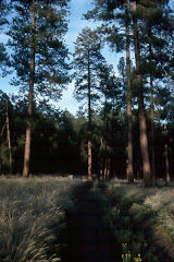
We set out up the road toward the gate entrance to the property.
Sweathouse Creek was running full — snowmelt white over moss-covered boulders, alder leaning into the current from both banks, a small diversion structure managing the flow toward the valley's irrigation network below. The Bitterroot Range is carrying ninety percent of normal snowpack this spring, and you could hear it in the creek. The mountains are not scenery here. They are the water supply. The Bitterroot Valley's farms and ranches have depended on snowmelt off this range for as long as people have worked this land, and the irrigation channels that distribute that water are as much a part of the valley's ecology as anything growing beside them.

Just before the gate, on the dry road shoulder, something grew that looked unremarkable — grass-like leaves, a flower spike just emerging, a small pink flag beside it. Laura stopped the group there. Toxicoscordion venenosum — meadow death camas. Laura and Hannah had been here before us, walking the property in advance, placing flags at every specimen she wanted the group to see. This was the first lesson, delivered at the threshold.
Death camas is a plant that exploits resemblance. Its grass-like leaves look like wild onion. Its white flower spike looks, at a certain moment in spring, like edible blue camas (Camassia quamash), the bulb that fed Indigenous peoples throughout this region for thousands of years and that Lewis and Clark's Corps of Discovery ate in quantity near the Lolo Trail not far from here. The confusion is not carelessness. It is the product of ecological proximity — the two plants share similar habitats and bloom at the same time of year. Every part of death camas is toxic — bulb, leaf, flower. Livestock have died from it. People have died from it. Laura named it plainly and moved on. The flag stayed in the ground.
Hannah held up her phone so the group could see: the field ID app confirmed the identification, the Latin name stark against the image.

We passed through the gate.
The site beyond is a conservation easement — land protected from development, held in trust for the ecological values it carries. Part of BRLT's ongoing stewardship work is understanding what those landscapes actually contain. That is where the Forest Service partnership matters. Laura Johnston and Hannah carry the scientific vocabulary and the field instincts to inventory a place systematically. Amanda Kimball, BRLT's lands coordinator, was there to document alongside the group.
We started at the dry end of things.

The rocky hillside above the valley floor held a community of plants adapted to shallow soil, fractured substrate, and full exposure. Indian paintbrush (Castilleja sp.) flared red-orange from the talus. Arrowleaf balsamroot (Balsamorhiza sagittata) spread its large basal leaves across the slope, the yellow flowers just past their peak. Creeping Oregon grape (Mahonia repens) held its yellow flower clusters low to the ground, its holly-like leaflets edged in purple-red. Silky lupine (Lupinus sericeus) had pushed up through the needle duff, its blue-violet racemes compact and precise. These are plants that know drought, that have made their arrangements with thin soil and long summers.

Laura and Hannah moved through this community with the ease of someone reading a familiar text, pointing, naming, noting. Pink flags marked every stop — their advance work making each pause intentional.
The ponderosa pines above were open-grown, their canopies high and wide, their bark plated in deep orange and gray. In the needle duff at their feet, young seedlings had germinated — small constellations of needles, each one a potential century. Western larch appeared in the mix as well, its needles soft and clustered — a deciduous conifer that would go gold in October and drop every needle before winter, a fact that still surprises people who expect all conifers to be evergreen. The small cones in the duff told a story of regeneration: this forest was doing what healthy forests do, given the chance.
 in yellow bloom")

Then the gradient shifted.
Moving toward the meadow, the soil deepened and darkened. Serviceberry (Amelanchier alnifolia) crowded the shrub layer, its pale flower buds still tight against red-tinged stems — in a few weeks it would be white with bloom, and later in summer the dark berries would feed birds and bears alike. Rocky Mountain maple (Acer glabrum) opened its fresh leaves and small flower clusters in the moist draws, the new growth nearly chartreuse against the darker forest. Alder thickened along the drainage edge, its spent catkins still hanging dry and articulated while fresh leaves opened around them. Chokecherry (Prunus virginiana) was leafing out as well — and on one branch, a thick black mass of Apiosporina morbosa, black knot fungus, a disease the valley's cherry family carries. Laura pointed it out without alarm. It is part of what the land holds.
Someone asked about the aspen grove at the meadow edge — whether those were all separate trees. Laura explained what the roots are doing underground: how what looks like a grove of individual trees is often a single clonal organism, one root system sending up hundreds of stems, potentially covering acres, potentially thousands of years old. You are not looking at a forest of separate things, she said, in effect. You may be looking at one thing. The group was quiet for a moment with that.
Then we stepped into the meadow, and a Western meadowlark was singing somewhere to the west. A California quail called from the shrub edge. The light was going golden.

Amanda Kimball had dropped to one knee in the meadow grass, turning a sedge specimen in her fingers, examining the sheath, the ligule, the seed head. The sedges — Carex and its relatives — are among the harder genera to work with in the field, but they are among the most important ecologically. Where sedges grow, water moves slowly, soils stay moist, and a different suite of animals finds what it needs.


What a conservation easement protects, in the end, is not a single species or a single view. It is a gradient — from the dry road shoulder where death camas waits at the gate, through the talus where paintbrush burns red and ponderosa parkland where lupine blooms in the duff, down into the wet meadow edge where sedges root in the dark soil, where alder crowds the drainage and snowmelt finds its way toward the valley floor and the irrigation channels beyond. The gradient is what matters. Protect only the pretty parts and you lose the functional whole.

Laura Johnston and Hannah brought their Bitterroot National Forest expertise to private land that evening because the partnership between BRLT and the Forest Service recognizes what a single institution cannot hold alone. Laura had walked the property before any of us arrived, placing flags, preparing the lesson. The science of what a landscape contains belongs to everyone who lives beside it — but first, someone has to go out and learn it.
We finished sometime after 6 at the Sweathouse Creek trailhead. The meadowlark was still singing.
Sam Lammie & Claude
![]()

No comments:
Post a Comment