A third piece on the Forest Service reorganization — on where the agency’s leadership has come from, and what that says about where its operational center belongs.
")
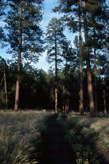
The Selway-Bitterroot Wilderness Area (from the Blodgett Overlook Trail, Bitterroot NF)
The two essays I posted earlier this month argued that the Forest Service’s operational center should not be moved to Salt Lake City, and that Missoula is the defensible alternative if a move is going to happen at all. Those pieces argued from water — the 1897 mandate to maintain favorable conditions of water flows, and the political culture of the proposed host state. This one argues from something less visible and, in its own way, more telling. It argues from where the agency’s leaders have come from.
Consider a sequence from the recent past. Dale Bosworth served as Regional Forester for the Northern Region — Region 1, headquartered in Missoula — from 1997 to 2001. In 2001 he became the 15th Chief of the Forest Service. Gail Kimbell was appointed Region 1 Regional Forester in December 2003; in 2007 she became the 16th Chief, the first woman to hold the office. Tom Tidwell was appointed Region 1 Regional Forester in 2007, succeeding Kimbell when she moved up; in 2009 he became the 17th Chief, and held the position for eight years.
Three consecutive Chiefs of the United States Forest Service, spanning the years from 2001 to 2017, came to the office directly from the same chair: the Regional Forester’s seat in Missoula, Montana. The Forest History Society records the fact without embellishment. Tidwell, it notes, was the third consecutive person promoted from Region 1 Regional Forester to chief. The pattern was remarked on at the time. When Tidwell’s appointment was announced in 2009, a Missoula newspaper asked why the last three chiefs had all come from that one region.
Bosworth, who had returned to Missoula after his own retirement, offered an answer. Region 1, he said, is the last of the wildlands in the lower 48 states — an excellent place to acquire a wide variety of experiences. More specifically, he described it as a training ground for bringing together the independent and conflicting interests of the Northern Rockies. The work of a Region 1 Regional Forester, in his telling, is the work of holding competing claims in productive tension — ranchers and wilderness advocates, timber and recreation, federal authority and state prerogative, tribal treaty rights and private property — across a landscape where those claims press against each other harder than almost anywhere else in the system. A leader who can do that work in the Northern Rockies, the reasoning goes, can do it for the agency as a whole.
What makes the modern sequence striking is that it was not the first time. The pattern reaches back to the agency’s founding generation.

Historical photograph of the Forester and Branch Chiefs, March 1924
Missoula became the official center for Forest Service operations in the Northern Rocky Mountain District in December 1908, when the regional office system was established. The district’s first leader was William B. Greeley; his assistant was Ferdinand Silcox. Greeley led the Missoula district through the catastrophic fires of 1910 — the Big Blowup that burned three million acres in two August days and shaped the agency’s thinking about fire for the next century. In 1911 Greeley was transferred to Washington, and Silcox succeeded him as district forester in Missoula, serving until 1917. In time, both men became Chiefs of the Forest Service: Greeley the 3rd Chief, from 1920 to 1928, and Silcox the 5th, from 1933 until his death in 1939.
Honesty requires a qualification. Neither Greeley nor Silcox went directly from Missoula to the Chief’s office the way Bosworth, Kimbell, and Tidwell later would; their careers ran through Washington and, in Greeley’s case, through a world war before they reached the top. And honesty requires acknowledging something else. The fire doctrine that Greeley and Silcox forged in the aftermath of 1910 — the conviction that fire could and should be suppressed wherever it appeared — became one of the agency’s defining commitments and, eventually, one of its most reconsidered. A century of fire ecology has complicated the lesson those men drew from the Big Blowup. The point is not that the leaders Missoula produced were always right. The point is that the agency kept turning to leaders formed there when it chose who would sit at the top.
That is the pattern, and it brackets the whole history of the Forest Service. Two of the agency’s first five Chiefs were formed in the Missoula office during the founding era. Three consecutive Chiefs came directly from the Missoula Regional Forester’s chair in the modern era. Across more than a century, the Northern Rockies have been, again and again, the ground where the agency’s leadership took shape.
I want to be careful not to overstate this. These were not people made by a single place. Bosworth earned his forestry degree at the University of Idaho and began his career on the St. Joe National Forest; before Missoula he had been Regional Forester in the Intermountain Region, headquartered in Ogden, Utah. Kimbell grew up in New England, hiking and fishing in the White Mountain National Forest, and trained at the University of Vermont and Oregon State. Tidwell grew up in Boise, trained at Washington State, and — worth noting in this context — served as a Forest Supervisor during the 2002 Winter Olympics in Salt Lake City. These were broad Western careers, formed across many forests and several regions. Missoula did not make them by itself. But the Missoula chair was, across two distinct eras, the seat the agency most often filled and then promoted from. Whatever that chair demanded, it demanded something the agency kept deciding it wanted at the top.
What it demanded, if Bosworth is right, was the capacity to govern contested ground without flattening the contest. That is a particular kind of institutional skill, and it is not produced by management training or by proximity to power. It is produced by doing the work in a place where the work is hard. The Northern Rockies are that place. The landscape is varied enough — boreal, montane, river valley, high-desert margin — that a leader encounters most of the agency’s ecological range. The politics are contested enough that a leader learns to build agreement rather than impose it. And the institutional density is high enough that a Regional Forester there is never far from the research, the fire operations, and the field experience that inform a sound decision.
This brings the argument to the present. The 21st and current Chief, Tom Schultz, did not come up through the federal line-officer pipeline that produced his three modern predecessors. His path ran through state lands and the private sector — director of the Idaho Department of Lands, leadership of the Trust Lands and Water Resources Divisions at Montana’s Department of Natural Resources and Conservation, and a period in the timber industry before his appointment. It is a different formation than Bosworth’s or Tidwell’s.
But it is not a formation from somewhere else. Schultz holds a master’s degree in forestry from the University of Montana — earned in Missoula. His Montana work in trust lands and water resources is, in its own register, public-trust work: the administration of lands and waters held for a beneficiary across time. His career has run through the same Northern Rockies country that Bosworth named as the agency’s training ground, even if it ran through state institutions rather than federal ones. The current Chief’s own formation, in other words, points back toward the same place.
That is the quiet argument of this piece. For more than a century, the leadership of the Forest Service has been forming in and around Missoula and the Northern Rockies — through the founding-era office that produced Greeley and Silcox, through the modern Regional Forester’s chair that launched three consecutive Chiefs, and now through a Chief whose own graduate training and state-lands career run through the same country. The agency’s leadership has a center of gravity, and it has never been in Salt Lake City. It has been in the place Bosworth called the last of the wildlands — the place the agency kept turning to when it needed someone who could hold contested ground together.
A reorganization that moves the operational center to Salt Lake City moves it away from that center of gravity. It does not move the agency toward its leadership; it moves it away from where its leadership has been formed. Missoula already holds the institutional density — the fire research, the smokejumpers, the aerial fire depot, the regional headquarters, the forestry school, and beginning this summer the National Forest History Museum. The leadership history points in the same direction the institutions do.
None of this requires a verdict. The case can simply be observed. Two of the first five Chiefs were formed in the Missoula office. Three consecutive modern Chiefs came directly from the chair there. The current Chief was trained in Missoula and built his career in the surrounding country. For more than a hundred years, the agency’s leadership has been forming in one identifiable place. The operational center belongs where the leadership has been forming.
A note on sources.
Leadership records from the Forest History Society biographies of William B. Greeley, Ferdinand A. Silcox, Dale Bosworth, Abigail (Gail) Kimbell, and Thomas Tidwell; the University of Oregon Special Collections inventory of the Greeley papers; the USDA Forest Service Intermountain Region past-regional-foresters record; and the official USDA Forest Service biography of Chief Tom Schultz. The 1908 establishment of the Missoula district office from contemporaneous Missoulian accounts. Dale Bosworth’s remarks on Region 1 as a training ground from a 2009 Missoulian article on Tidwell’s appointment, as quoted by the Forest History Society. Lead photograph of the Selway-Bitterroot Wilderness by the author. Historical photograph of the Forester and Branch Chiefs, March 1924, from U.S. Forest Service historical records (image 186996).
Samuel Lammie is a geospatial professional (GISP) and former federal employee. His Forest Service career included a capstone role as Northern Region Geospatial Program Manager in Missoula. He served as a Peace Corps Volunteer.
This piece was produced in collaboration with Claude, an Anthropic AI assistant. The argument, the sources, and the editorial judgments are the author’s.

")