Updated Wildfire Status (June 2023)
The latest preparedness levels (June 9th) for the US and Canada are at PL 2 and 5, respectively. Conditions in the US are relatively stable and reflect a cooler than average spring with varying amounts of precipitation. On the other hand, to our north Canada is experiencing extreme wildfires as a result of severe drought conditions with elevated temperatures and dry fuels - these are a volatile mix when combined with lightning strikes and are causing the majority of fires in eastern Canada.
Severe wildfires on both east and west sections of Canada have resulted in thousands of Canadians being evacuated and thousands of acres of forest lands being impacted. The majority of these wildfires are located in the Canadian boreal forest. Typical suppression tactics in Canada are similar to Alaska in that many wildfires are left to burn in unpopulated areas and are only attacked, quoting a Canadian firefighter on Twitter, to "...protect values at risk, i.e., infrastructure, communities, critical habitat or culturally significant features on the landscape, we’ll map them and maybe try to burn them to natural barrier, fight one flank and let the rest roll (limited action) but we are not putting them out." The current wildfire numbers across Canada are well over 400 with roughly 50% of these still being labeled as "out of control."
Many of these large wildfires in the US and Canada that extend across thousands of acres often are left to burn - awaiting the approaching winter to finally extinguish the remaining flames. Canadian firefighters are expecting the worst - the current severe conditions are unusual this early in the year and portend a long fire season.
Thankfully, the unexpected Canadian smoke plumes that have covered and severely impacted air quality over the last several weeks in the eastern US have abated. Current air quality conditions can be monitored on the AirNow site: Fire and Smoke Map (airnow.gov).
Spring 2023 Wildfire Status (May 2023)
Another fire season is upon us and so far in the US it has been below average - 16,000 wildfires have burned over 477,00 acres as of May 19, 2023. A relatively mild, early fire season in the US reflects a cool and wet spring across the country. While the US preparedness level (PL) is at a PL of 2 across the country, the province of Alberta in Canada has now declared a wildfire emergency due to dry conditions and high winds with over 80 active wildfires burning across 900,000 acres. Canadian officials have evacuated more than 20,000 residents across the country, mainly in western Canada.
Canada is at national preparedness level 5, indicating full commitment of national resources is ongoing, demand for resources is extreme, and international resources are being mobilized. Alberta is at level 5, indicating assistance is required, Saskatchewan is at level 4, British Columbia, Northwest Territories, Nova Scotia and Parks Canada are at level 3 with all other agencies at preparedness level 2 or 1.
Causes of Wildfires
Research has indicated that nearly 85% of all wildfires are caused by humans (and nearly all fires in western Canada in early 2023 are human-caused):
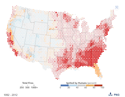
Humans—not lightning—trigger most wildfires in the United States. According to a study published in February 2017 in the Proceedings of the National Academy of Sciences, 84 percent of the blazes that firefighters were called to fight between 1992 and 2012 were ignited by people. Some common ways that people start fires include discarding cigarettes, leaving campfires unattended, and losing control of prescribed burns or crop fires. Sparks from railroads and power lines, as well as arson, also routinely cause wildfires.
University of Colorado scientist Jennifer Balch and several colleagues came to their conclusion after analyzing reports of 1.6 million wildfires from a comprehensive’s fire occurrence database maintained by the U.S. Forest Service. As shown by the map above, almost all (80 percent or more) of the fires in the Mediterranean ecosystems of central and southern California, the temperate forests of the eastern United States, and the temperate rainforests of the Pacific Northwest are caused by humans. In contrast, lightning started the largest percentage of fires in the forests of the Rocky Mountains and the Southwest. In Florida, which is moist but has a great deal of lightning, between 60 and 80 percent of wildfires were caused by people.
The researchers also found that human-ignited fires tripled the length of the wildfire season. Though lightning-ignited fires were clustered in the summer, human-ignited fires occurred in the spring, fall, and winter as well, times when forests tend to be moist. During these seasons, people added more than 840,000 fires—a 35-fold increase over the number of lightning-started fires. In the eastern United States, fire activity became more extensive in the spring; in the West, human-ignited fires tended to extend the fire season in fall and winter. Despite the high number of incidents, human-ignited wildfires accounted for just 44 percent of the total area burned because many of them occurred in relatively wet areas and near population centers, where firefighters likely could quickly extinguish the fires before they spread.
The researchers also compared the wildfire reports to other satellite-based measurements of fire activity and forest health. For instance, by comparing to a Landsat-based record of burn scars—known as the Monitoring Trends in Burn Severity (MTBS) project—they showed that both human-ignited and lightning-ignited wildfires have grown larger and more severe since 1992. For lightning fires, burning increased in mountainous parts of the West—not because there was more lightning, but because a warmer climate dried out forests. Among human-caused fires, there was an increase in large fires in the spring months in the Great Plains, possibly because climate change has prompted agricultural activities earlier in the year, Balch said.
- Balch, J. et al, (2017, February 27) Human-started wildfires expand the fire niche across the United
- States. PNAS.
As a private landowner many of us are tempted to simply accept the fact that we live in a wildland-urban interface and that we can rely on local volunteer fire departments for protection. The reality is that if we wait until that day arrives when there is a threatening front of wildfire and an evacuation has been ordered there may be precious little time to evacuate ourselves, our pets, and our livestock. Volunteer fire departments are ready at a moment's notice to respond to a wildfire, but it may be physically impossible for fire fighters to physically deal with every threatened structure - even with sophisticated fire-fighting equipment.


No comments:
Post a Comment